Where is the most toxic air in Cardiff?

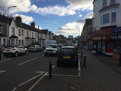
Cardiff has many tight, congested streets that act as hot-spots for NO2.
Since traffic emissions are the main source of air pollution in the city, the worst areas are typically those with narrow congested roads or major junctions. The four areas most visibly in breach of national air pollution guidelines include:
- The city centre: Westgate Street, St Mary Street and Castle Street all have dangerously high levels of NO Castle Street in particular has the worst in the city, at 52.4 µg/m3.
- Ely Bridge: This site in west Cardiff suffers from particularly bad congestion as multiple roads converge on a single bridge.
- Stephenson Court, Newport Road: NO2 levels aren’t wonderful along the length of Newport Road, but are particularly bad at the junction with City Road, as Cathays traffic meets those entering and leaving the city.
- Llandaff: The road outside the cathedral is a narrow, truncated artery of the city, which is often blocked up by traffic visiting Cardiff from the northwest.
Although the council has reduced the levels of pollutants at each site in recent years, the National Audit Office (NAO) predicts that most of the above will not be within regulated levels until 2021.
Cardiff’s air quality has been ranked among the worst ten cities in the UK by the World Health Organisation.
The report found Cardiff’s air had a higher concentration of sooty particles smaller than 2.5 microns (PM 2.5) than was considered healthy by WHO guidelines.
PM 2.5 has been linked with heart disease and lung inflammation, with their small size meaning that they are more likely to be inhaled and penetrate deeper into a person’s respiratory system. It is estimated that 143 deaths each year in Cardiff are the result of particulates.

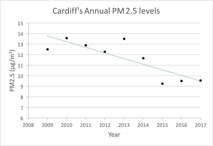
Whilst Cardiff’s particulate concentrations have improved over the last decade, they are still among the worst in the country – 10 µg/m3 is considered the ‘safe’ threshold by WHO.
The city similarly has issues with nitrogen dioxide (NO2). NO2 is derived primarily from car fumes and can lower the body’s immunity to diseases like flu, whilst also causing acute respiratory diseases in children.
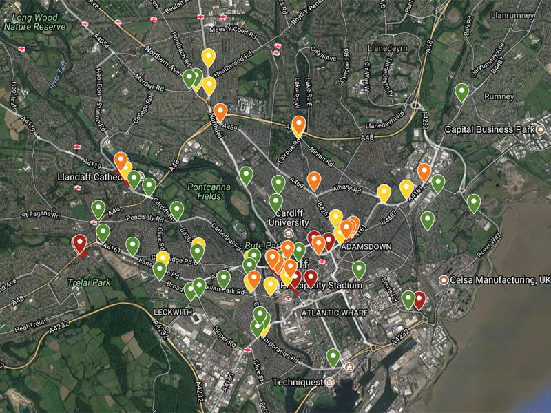
Due to the high levels of traffic in Cardiff, there are several areas which routinely suffer from a dangerous build-up of NO2, defined by a concentration greater than 40 µg/m3. Cardiff Council has designated these zones as AQMAs (Air Quality Management Areas) and has been focusing on improving these pockets of poor air quality, with limited success. It is apparent that a more holistic approach is required.
View the interactive map of Cardiff’s NO2 concentrations below:
Red = high pollution (>40 µg/m3), orange = medium-high (35-40 µg/m3), yellow = medium-low (30-35 µg/m3) and green is effectively safe (<30 µg/m3). The Council’s AQMAs are circled in red. Data provided courtesy of Air Quality in Wales
Craig Lewis, creator of the council’s annual progress report, said: “In order to improve the air quality in Cardiff, action needs to be taken across the city as whole and it is acknowledged that road traffic emissions are the primary contributing factor to poor air quality in Cardiff”.
Some of the methods suggested in the report included the creation of a ‘Clean Air Zone’, which would prevent vehicles with particularly high emissions from entering certain parts of the city. It was also suggested that the improvement of Cardiff’s air quality should be the responsibility of the Cabinet, rather than the Council, to ensure that it is a consideration in all future plans.
Where is the most toxic air in Cardiff?

Cardiff has many tight, congested streets that act as hot-spots for NO2.
Since traffic emissions are the main source of air pollution in the city, the worst areas are typically those with narrow congested roads or major junctions. The four areas most visibly in breach of national air pollution guidelines include:
- The city centre: Westgate Street, St Mary Street and Castle Street all have dangerously high levels of NO Castle Street in particular has the worst in the city, at 52.4 µg/m3.
- Ely Bridge: This site in west Cardiff suffers from particularly bad congestion as multiple roads converge on a single bridge.
- Stephenson Court, Newport Road: NO2 levels aren’t wonderful along the length of Newport Road, but are particularly bad at the junction with City Road, as Cathays traffic meets those entering and leaving the city.
- Llandaff: The road outside the cathedral is a narrow, truncated artery of the city, which is often blocked up by traffic visiting Cardiff from the northwest.
Although the council has reduced the levels of pollutants at each site in recent years, the National Audit Office (NAO) predicts that most of the above will not be within regulated levels until 2021.


